Blog

  • A new record low before the ice increase

    A new record low before the ice increase

    Arctic sea ice extent for September 16, 2012

    The summer sea ice is increasing again as winter looms but recorded its lowest ever extent since satellite measurements began in 1979. The ice on September 16th was significantly lower than the previous record year of 2007.

    On September 16, 2012 sea ice extent dropped to 3.41 million square kilometers, 760,000 square kilometers below the previous record minimum extent in the satellite record, which occurred on September 18, 2007.

    That means there less ice in the Arctic which would cover all of Norway, Denmark and Finland combined.

    The National Snow and Ice Data Center reports that in response to the setting sun and falling temperatures, ice extent will now climb through autumn and winter. However, a shift in wind patterns or a period of late season melt could still push the ice extent lower. The minimum extent was reached three days later than the 1979 to 2000 average minimum date of September 13.

    This year’s minimum is 18% below 2007 and 49% below the 1979 to 2000 average.

    Overall there was a loss of 11.83 million square kilometers (4.57 million square miles) of ice since the maximum extent occurred on March 20, 2012, which is the largest summer ice extent loss in the satellite record, more than one million square kilometers greater than in any previous year.

    Source:

    NSIDC

  • Russia to build a new icebreaker

    Russia to build a new icebreaker

    Cargo Ship

    Russian is building a new icebreaker to be delivered in 2015. The shipbuilding company Baltiisky Yard oversees the project of the 25 megawatt vessel to serve the Russian Arctic.

    The ice breaker will be the biggest of Russia´s diesel-engine icebreakers and designed to operate in heavy winter ice conditions. Russias fleet will include nuclear and non – nuclear powered vessels.

    According to the company, the vessel will be 146,8 meters long and have a deadweight of 22258 tons. It will have a crew of 38 and will be able to operate autonomously for 60 days in up to two meters thick ice.

    The construction contract is worth close to 7,5 billion RUB.

    So far ships have been chartered out on research operations, search and rescue emergencies as well as touristic expeditions.

    Sources

    Maritime Professional

  • INTERACT calls for proposals

    INTERACT calls for proposals

    Permafrost research site in Ny Alesund, Svalbard

    The INTERACT project is commencing its autumn period and is now calling for proposals for the next one.

    A call for summer 2013 and winter 2013/2014 will be open until 31st of October.

    The INTERACT project under EU FP7 has a Transnational Access program that offers access to 20 research stations in northernmost Europe and Russian Federation.
    The sites represent a variety of glacier, mountain, tundra, boreal forest, peatland and freshwater ecosystems, providing opportunities for researchers from natural sciences to human dimension.

    Transnational Access includes:

    • Free access for user groups/users to research facilities and field sites, including support for travel and logistics
    • Free access to information and data in the public domain held at the infrastructures

    The call for proposals for summer 2013 and winter 2013/2014 field seasons is open on the INTERACT website until 31st October, 2012.

    For additional information, visit the INTERACT website or contact WP4 coordinator Hannele Savela, hannele.savela(at)oulu.fi, or WP4 leader Kirsi Latola, kirsi.latola(at)oulu.fi.

  • Compare sea ice extent by dates

    Compare sea ice extent by dates

    Sea ice extent on the 19th of August in 1982, 1992, 2002 and 2012.

    A website by the university of Illinois, USA, allows users to compare sea ice extent between exact dates since 1979.

    The user-friendly website clearly demonstrates the sea ice extent with data from the National Center for Environmental Prediction/NOAA, NSIDC, U. Bremen.

    By selecting two different dates comparison can be made between pictures that show the extent.

    The picture on the right actually shows four pictures, but the system compares two. The picture, expandable by clicking on it, shows the sea ice on August 19th in 1982, 1992, 2002 and 2012.

    Comparing even the last 10 years shows incredible changes in the sea ice extent.

    The website also demonstrates all the pictures in a video showing the extent from 1978-2006 here.

    Click here to see and test the system.

    Source:

    CryoSphere Today

    Link to the system

  • Canadians to cross the North Pole

    Canadians to cross the North Pole

    Polar bears

    Russian – Canadian expedition will aim to cross the North Pole. The voyage will try to connect the northern Russian shore with the Canadian one.

    The trip is expected to be 8.000 kilometers long. The travel is scheduled to start in February 2013. It is expected to reach Canadian shore in the end of May 2013. It will be led by the Russian captain – Vladimir Chukov.

    Eight explorers will set out in two specially designed vehicles with overinflated tires that allow for travel over the snowdrifts and dangerous Arctic ice cap, where above-freezing temperatures in the summer months can cause the ice to break up.

    The expedition will conduct the scientific research to include the observation of the polar bear populations at the Pole and their adaptation to changing Arctic climate. The outcome of the research will be shared with scientists world – wide.

    The expedition will serve for some of the first tests of Russia’s GLONASS satellite navigation technology, Moscow’s bid to challenge the dominant U.S. global positioning system (GPS) as reported by Barents Observer.

    Source

    Barents Observer

  • Successful journey of the Snow Dragon continues

    Successful journey of the Snow Dragon continues

    The Snow Dragon

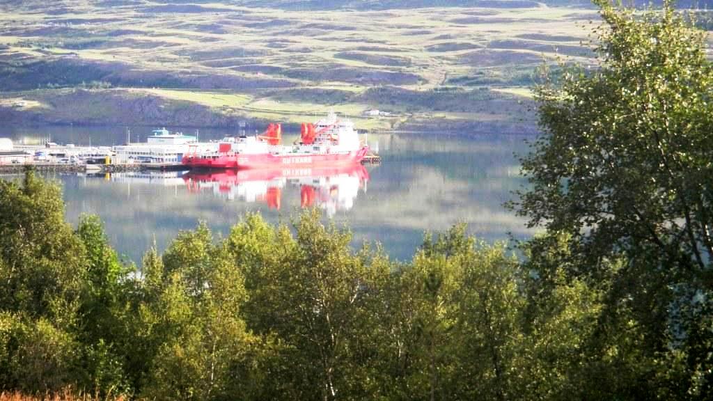
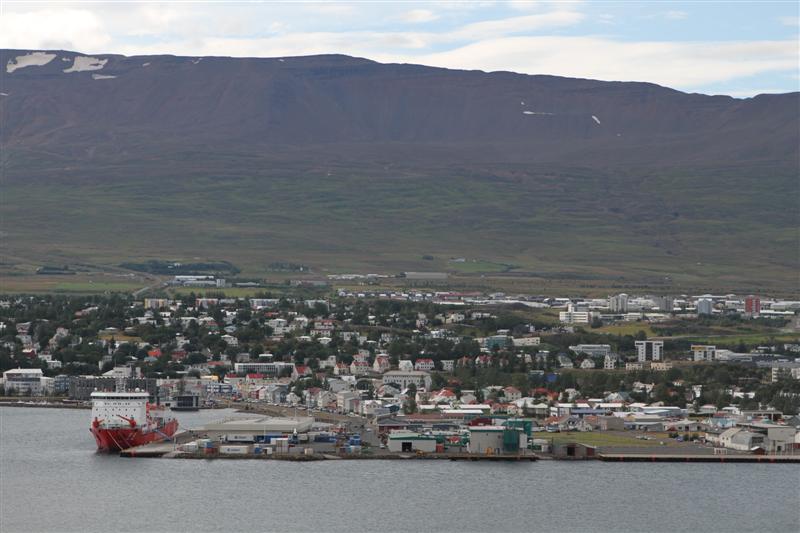
    The journey of the icebreaker Xue Long from Iceland to China, via the Arctic Ocean, has been successful so far. With the decreasing sea ice extent, the research ice-breaker has been able to sail through the Central Arctic Shipping Route without a support from nuclear powered vessel.

    Due to such an ice conditions, the research ice-breaker was able to operate via Fram Strait and carry on a high Arctic region to the east.

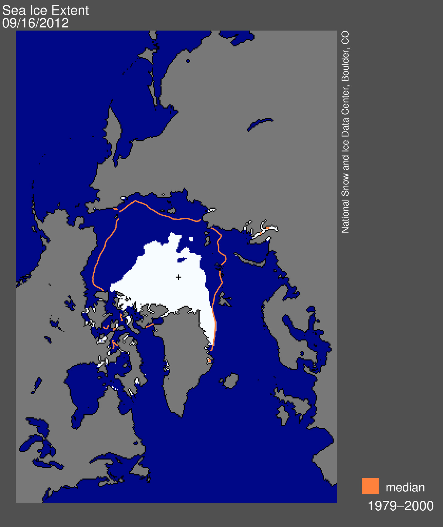
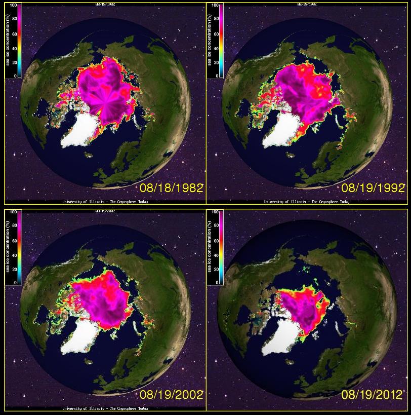
    Arctic sea ice extent fell to 4.10 million square kilometers on August 26, 2012. This was 70,000 square kilometers below the September 18, 2007 daily extent of 4.17 million square kilometers.

    Geological research: Gravity core launched in the Iceland Sea.

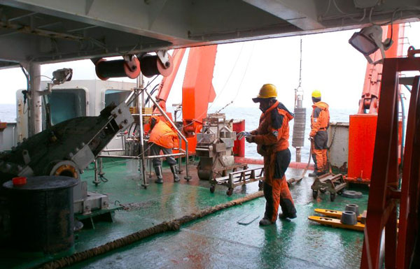
    Oceanographic, biological, geological and geophysical research was carried out in the Iceland Sea and Greenland Sea on the route north and meteorological observations are maintained throughout the expedition.

    Various satellite images are received for navigation through the sea ice.

    Benthic samples, from the shore lines of Icelandic waters were taken in order to prove benthos great increase in region that extends away from the land mass.

    Benthic sampling techniques are essential to habitat mapping studies since they provide the ‘truth’ data on the actual composition of the seafloor. When they are commonly used in conjunction with either a remote sensing or an acoustic technique, they are said to ‘ground truth’ seafloor classifications.

    Benthic sample from the Iceland Sea

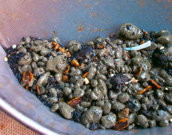
    If samples are collected in high enough densities over survey areas they can be used to establish distributions and define habitats.

    Biological and geological/physical samples taken by the Geological Team from the Xue Long are to be taken separately from different grabs.

    Sailing out from Iceland, the Snow Dragon reached the region east of Jan Mayen, where in the good weather it was possible to see the Beerenberg volcano.

    It is the world’s northernmost sub aerial active volcano. The volcano is topped by a mostly ice-filled crater about 1 km (0.6 mi) wide, with numerous peaks along its rim including the highest summit, Haakon VII Toppen, on its western side.

    The upper slopes of the volcano were observed to be largely ice-covered, with several major glaciers including five which reach the sea.

    No scientific research was conducted by teams, nevertheless the elevation was difficult to be missed.

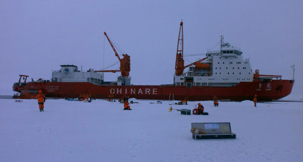
    Currently the vessel is heading up North, aiming to cross the North Pole. The ice conditions were reported as being almost 3 meters thick. The Snow Dragon is partly being followed by the Norwegian coast guard.

    Please, see the route of the Chinese research ice breaker on Interactive Mapping System.

    Source

    CHINARE5

  • Akureyri 150 Years Old Today

    Akureyri 150 Years Old Today

    Akureyri birthday

    Regardless of the vast wilderness and large uninhabited areas of tundra, snow and ice, the Arctic has a long history of inhabited communities within all eight Arctic states.

    One of them is Akureyri, the home of Arctic Portal and capital of northern Iceland, which today celebrates its 150th birthday. All 13 kindergartens and 10 primary schools of the town were invited to a feast at the town centre square, in which they participated in a sing-along, listened a local band Hvanndalsbræður and were served a birthday cake.

    Akureyri - 150 years old celebration

    Throughout the year the town has organized a wide range of events celebrating the 150th birthday and among other things many projects have been initiated to exhibit the history of the town.

    Sources

    Akureyri Town Homepage

    Visit Akureyri Homepage

  • Nine vessels have sailed through NSR this summer

    Nine vessels have sailed through NSR this summer

    Transport ship

    With the continuous melt of Arctic sea ice, the Region might become all free of summer ice within a next decade.

    Previous year which was marked as the longest sailing season for the Northern Sea Route, managed to handle 34 vessels. The total cargo transported, reached 820.000 tones.

    So far the year of 2012 managed to handle only 9 vessels on the Northern Sea Route. However, if the sailing season extends, this year might become new record for the new transportation path between Asia, Northern part of Europe and North America.

    Nuclear powered ice breakers have been escorting vessels in transit in convoys this summer as the ice level was extremely law. This situation was different from the one which occurred in 2011, when nuclear powered ice breakers had to follow one ship at the time in order to bring it through thick Arctic ice.

    The first two vessels to sail through Northern Sea Route this summer were Russian ´Indiga´ and ´Varzuga´ which transported diesel fuel.

    ´Nordic Odyssey´ and ´Nordic Orion´ sailed from Murmansk in northern Russian to ports in China with close to 70.000 tons of iron ore concentrate.

    The gas tankers ´Marilee´ and ´Palva´ both owned by Murmansk Shipping Company, each transported close to 60.000 tons of gas condensate to South Korea.

    Also ´Vengeri´, the tugboat and the Chinese non – nuclear ice breaker ´Xuelong´ were escorted along the Northern Sea Route this summer while sailing to the northern hemisphere.

    The scientists report that the situation on the Northern Sea Route meets the average standards. The path from Kara Gate to New Siberian Islands seems to be totally ice free, however the part of the way in East Siberian Sea, seems to be more difficult than recorded last year.

    Currently the trip via Northern Sea Route takes 9 – 11 days on average speed of 12 knots.

    Source

    Barents Observer

  • The Snow Dragon bound for North Pole

    The Snow Dragon bound for North Pole

    Xuelong stationed in Akureyri, Iceland

    The Chinese research ice – breaker Xuelong, which left Akureyri in the northern part of Iceland, on Monday evening, is now on the way, to be the first non – Russian icebreaker to sail the transpolar route, straight across the top of the globe.

    Last week, the Snow Dragon completed the Northern Sea Route, reaching Reykjavik, Iceland on Saturday the 17th of August and then after spending the day in Akureyri, started the journey back to Asia.

    The scientists and the crew on board will try to prove that there is a future possibility of using Central Arctic Shipping Route for international navigation during the summer months.

    Currently, the vessel is just about to reach the Barents Sea.

    The M/V Xue Long is an A2-class ice-breaker with capability of breaking ice of 1.1 meters thickness. It was originally built as a cargo ship for Polar Regions by the Kherson Shipyard in Ukraine. After modifications in 1994 it became China’s first research ice-breaker. The vessel belongs to the Chinese Arctic and Antarctic research expeditions (CHINARE).

    The vessel is 167 meters long and 22.6 meters wide. It has a full-loaded draft of 9 meters, a full-loaded displacement of 21,250 tons and a cruising radius of 12,000 nautical miles. Two helicopters can be carried at the same time.

    Source

    Chinare5

  • Xuelong to sail through future central route

    Xuelong to sail through future central route

    Xuelong in the port of Akureyri

    The Chinese icebreaker Xuelong is heading to the North Pole. The CHINARE5, Chinas Fifth National Research Expedition, is aiming for the future central Arctic shipping route on its way back to China.

    This historic voyage is hoping to break the ice at the North Pole in an effort to show that it is indeed possible to sail an icebreaker through the route.

    The central Arctic shipping route is to many the most feasible route in Arctic shipping, as it is the shortest way through the Arctic.

    Xuelong will carry out more research in the Arctic Ocean on its way back to China, after successfully conducting extensive research on route to Iceland in the summer.

    The Xuelong sailed the Northern Sea Route, along the coast of Russia, in its journey. It is scheduled to be in Shanghai in the end of September.

    Source

    Chinare5