Blog

  • High hopes for Dreki oil

    High hopes for Dreki oil

    Map of the Dreki area

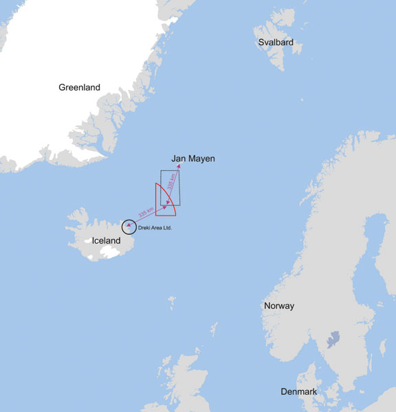
    There are high hopes for oil in the Dreki Area, south of Jan Mayen and North of Iceland.

    Norway and Iceland are joint owners of the area and could potentially benefit both countries.

    New samples are impressive and could increase interest in the area. Although the samples are positive, they are confidential, and will only be given to those who will search in the area.

    Specialist from Norway met their colleagues from Iceland last week. These samples were on the agenda, and next explorations which will be conducted soon.

    Þórarinn Sveinn Arnarsson, project manager for the Icelandic Energy Administration, told RÚV that further exploration is mostly on the Norwegian side.

    “A new exploration will most likely go to the area next summer, but that will also depend on what else we find from the last survey, samples are still being researched,” he said.

    A report from the company that conducted the research will be ready next month.

    Bidding for the search will then open in April.

    Sources

    RÚV (Icelandic National Television)

  • Barents-region ice free

    Barents-region ice free

    The satellite image shows the difference from the median ice edge and the ice today

    Very little sea ice is in the Barents region for this time of year. This indicates that this trend will continue and sailing will become easier by every year.

    Satellite images show that the waters north of Spitsbergen and north of Novaya Zemlya is not covered with ice, which is unusual for this time of year.

    A NSIDC map from 9th of January clearly shows how little ice is in the area. The Kara gate and the Pechora Sea in the eastern Barents Sea are both usually ice-covered this time of the year, but not now.

    The entire west coast of Novaya Zemlya is also ice-free.

    Sources

    Barents Observer

  • Greenland seeks help to lift EU ban

    Greenland seeks help to lift EU ban

    Seal is yawning

    Greenlanders are counting on Denmark to raise the issue of EU ban on import seal products, due to a burgeoning seal population in the Arctic regions. Denmark has the presidency of the EU which it took over i the beginning of 2012.

    Politiken reports that the Greenland Fisheries and Hunters Organisation KNAPK is hoping that the important seal hunting will be lifted so the seal population will continue to grow normally, and fish stocks as well.

    “Hunting seal and sealskin production ensures employment throughout Greenland and in particular in the outlying regions. Seal hunting and skin production helps raise living standards and livelihoods for hunters in our country,” KNAPK Chairman Leif Fontaine told Sermitsiaq in Greenland.

    Fontaine says that the EU’s ban has wrecked the worldwide trade in indigenous seal products, but equally importantly is threatening both the seal population and fish stocks in the Arctic regions. “We are concerned that the import ban on seal products is harming the eco-systems in our waters,” Fontaine says, adding the increasing population of seals is a ‘ticking bomb’ under the Greenland fishing industry.

    “Greenland’s Nature Institute has documented that the 17.5 million seals in the North Atlantic at 16 million tonnes of fish and shellfish each year,” Fontaine says. “At the same time we are seeing emaciated seals across all of the Arctic and are concerned that the seals are dying of hunger,” he adds.

    Fontaine notes that Denmark is legally bound to secure the livelihoods of indigenous Greenland hunters.

    Sources

    Politiken

    Sermitsiaq

  • Another major oil find for Norway

    Another major oil find for Norway

    Oil rig

    Norway has found the cornerstone of its oil production for the next year. The Barents Region of Skrugard is thought to give Norway up to 900 million barrels of oil.

    Aker Barents oil rig made the discovery in the Havis area. Statoil announced the found today.

    The Havis area will produce 200-30 million barrels but the surrounding area up to 600 million barrels.

    This is the second major discovery in the last nine months, much to the delight of Norwegians.

    “This found will be profitable both for Statoil and for Norway,” the president of Statoil, Helge Lund, announced.

    This is a new area which is very rich in oil. The one who searches, will find oil. There is a lot of research behind this,” Lund said.

    “Since the last major finding in 1997 we have made around 250 researches which is a major task,” he said.

    Sources

    NRK

  • Norway to send gas through the NRS

    Norway to send gas through the NRS

    Map of the Northern Sea Route

    Norway hopes to use the Northern Sea Route in a few months. Increased shipping saw 27 vessels using the route last year, a huge increase like indeed in the Northern Sea route.

    They want to transport gas from the Snowhite area to Asia. An LNG tanker will sail between Hammerfest in Norway to Japan as soon as the ice is thin enough.

    The vessel, Ribera del Duera Knutsen, is strentghened for sailing in sea ice. In fact it is the only LNG tanker in the world with an 1A class permission for sailing in ice.

    The sailing would take around 20 days, a big improvement from the route through the Suez Canal used today. This means the ship can go three tours next summer.

    “We have not been in contact with Statoil about the transport but technically it is possible,” Synnøve Seglem from OAS Shipping said to the NRK. “It is of course a feasible option for everybody,” he added.

    Sources

    NRK

  • 18.000 tons of junk to be removed

    18.000 tons of junk to be removed

    Old oil barrel dump

    Around 18.000 tons of scrap metal will be removed from the Arctic in 2012 by Russia. The country is cleaning up the Arctic and hundreds of millions of rubles will be injected to the program.

    The Arctic Islands of Russia are full of junk, causing environmental hazards. This year the program will focus on Svalbard and Amderma.

    Amderma is planned to become a key site in the development of offshore oil and gas fields in the western part of the Russian Arctic and an important base for traffic along the Northern Sea Route.

    A staggering 114.000 tons of local scrap stockpiles are thought to be in Amderma.

    Over 1800 empty fuel barrels were transported from Wrangel Island to Arkhangelsk last year. That is only a drop in the bucket since 250,000 barrels holding some 40 to 60,000 tons of oil products are still in the area.

    Other kinds of waste include abounded aircrafts, rusty broken radar stations, different kind of Arctic vehicles and other leftover garbage.

    Sources

    BarentsObserver

    Nyaryana Vynder

  • No radioactive materials leaked after fire

    No radioactive materials leaked after fire

    Yekaterinburg submarine on fire

    No radioactive materials leaked from the nuclear submarine Yekaterinburg who caught fire yesterday. The submarine was in a floating dock which caught fire.

    Helicopters and boats were used to put out the massive fire which could be seen miles away.

    Russian oficcials say that no real danger was in place of radioactive materials leaking. The reactors were shut down before the ship docked and all missiles were removed.

    Nine people were sent to a local hospital with injuries because of the massive smoke.

    The naval yard is located in a close military area. The nearby city of Severomorsk is the headquarters of the Russian Northern fleet.

    Sources

    BarentsObserver

    Ria Novosti

  • Russian fishing vessel freed from ice

    Russian fishing vessel freed from ice

    Sparta in the ice.

    The Russian fishing vessel Sparta is free from the ice which held the ship for nearly two weeks.

    The 48-metre (157-feet) Sparta, with a crew of 32, had been anchored to the Antarctic ice shelf around 2,000 nautical miles (3,700 km) southeast of New Zealand after ice ripped a hole in its hull and it started taking on water on Dec 15.

    The ship will be escorted to open water where it will meet its sister ship.

    No heavy fuel leaked from the ship, only a small amount of light hydrolic oil.

    Here is a video from Reuters where the ship is shown, and its repairs as well.

    Sources

    Reuters

  • Western Greenlands melts fast

    Greenland heat map

    The melting of the Greenlandic glacier is rapid. The record of 2010 was not broken this year, yet it was over the long term average melt.

    The National Oceanic and Athmospheric Administration (NOAA) has compiled the melting days in an image which shows where the melting occurs.

    Melting was exceptionally high over the western mid-elevations, and the map shows the area swathed in orange.

    In some places, the melt season lasted up to 30 days longer than average (the top of the scale corresponds to anomalies 25 days or more), and it affected 31 percent of the ice sheet surface, making 2011 one of just three years since 1979 where melt area exceeded 30 percent.

    According to the Arctic Report Card, ice mass loss from Greenland in 2011 was about 430 gigatons, enough ice to raise global sea level by just over 1 millimeter.

    Source: NOAA

  • CrySat to enhance marine safety

    CrySat to enhance marine safety

    Demonstration of the measurement of sea level.

    The European Space Agency will use its powerful satellite for monitoring weather conditions to enhance marine safety. This will benefit the Arctic as the CryoSat is designed for measuring thickness of ice.

    ESA’s CryoSat mission has been gathering detailed information on the thickness of Earth’s ice since its launch in 2010. Through international collaboration, this state-of-the-art mission will broaden to monitor the weather.

    With the satellite scientists now have data to research and conclude about the understanding of the relationship between ice, climate and sea level.

    The CryoSat moves from pole to pole and will now measure the measure the sea level and the height of waves.

    From February this new technology will start for this important work which will benefit throughout the world.

    The image on the right shows mweasurments of sea level, when tested near Australia. The green is 0 but the yellow to red is high and light blue to dark blue belov sea level.

    Sources

    European Space Agency